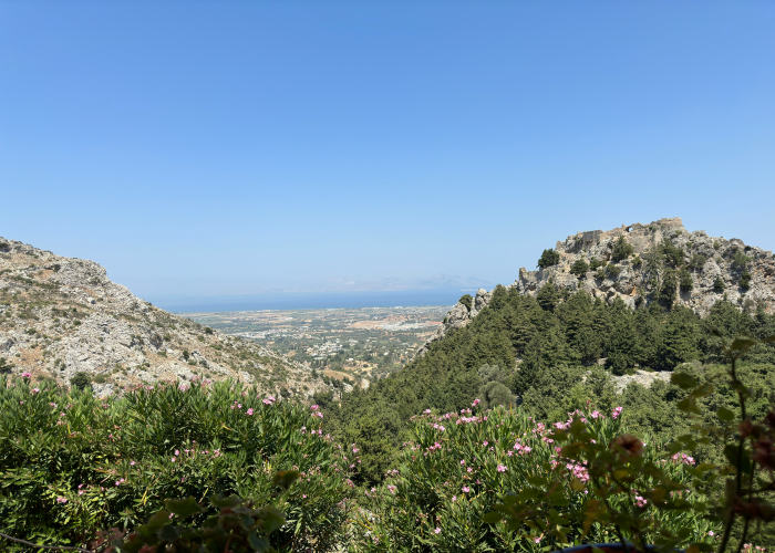
The Allgäuer Höhenweg is one of the most scenic and rewarding high-altitude trails in the Bavarian Alps, offering panoramic views, rugged peaks, and authentic alpine experiences. Stretching across Germany’s southern Bavarian region, it attracts hikers from around the world, particularly from the USA, UK, Australia, and Germany. This guide provides a detailed, practical overview for planning a safe and memorable trek. Allgäuer Höhenweg in Bavarian Alps, Tour & Trek.
Overview
Location: Bavarian Alps, Allgäu region, Germany
Why it’s famous:
- Offers spectacular ridge hiking with panoramic views
- Passes through alpine meadows, rocky summits, and charming villages
- Popular for multi-day treks and day hikes
- Combines natural beauty, traditional alpine huts, and regional culture
The trail is renowned for its well-marked routes, varied terrain, and opportunities to experience both challenging alpine sections and more moderate hiking paths. Hikers enjoy picturesque valleys, clear streams, and views of neighboring peaks, making it a top choice in the Bavarian Alps.
Best Time to Visit
- Summer (June–September): Ideal weather, fully accessible trails, lush green meadows
- Spring (May–June): Early season flowers and fewer crowds, but some snow patches remain
- Autumn (September–October): Cooler temperatures and stunning foliage
- Winter (November–March): Trail may be inaccessible due to snow; limited low-altitude hiking possible
Tip: The most recommended months are July to September for optimal trail conditions and daylight.
How to Reach
By Air:
- Munich International Airport (MUC): Approx. 2–3 hours by car/train
- Memmingen Airport: Closer option for southern Allgäu access
By Train:
- Regional trains connect Munich, Kempten, and Füssen to Allgäu towns
- Local buses serve trailheads
By Road:
- Accessible via highways from Munich, Innsbruck, or Salzburg
- Ample parking at main trailheads and alpine hut areas
Entry Fees and Permits
- Trail access is free, as it runs through public alpine areas
- Optional fees for cable cars or mountain lifts (approx. €15–€25, subject to change)
- Some nature reserves may request small donations
Tip: Check for seasonal closures or maintenance before planning your trek.
Food Availability and Meal Options
- Alpine huts (Almen): Offer local Bavarian cuisine like cheese, sausages, and bread
- Restaurants in villages: Found along major trail points
- Self-catering: Picnic-friendly spots available with scenic views
- Water: Bring refillable bottles; some huts offer spring water
Packing List and Essentials
- Footwear: Sturdy hiking boots with ankle support
- Clothing: Layered outfits for changing weather, moisture-wicking fabrics
- Rain Gear: Waterproof jacket, pants, and backpack cover
- Backpack Essentials: Water, snacks, first aid kit, map, compass, camera, sunscreen, hat, sunglasses
- Optional: Hiking poles, trekking gloves, binoculars for wildlife spotting. Allgäuer Höhenweg in Bavarian Alps, Tour & Trek.
Safety Tips and Local Regulations
- Stay on marked trails; ridges can be exposed and steep
- Check weather forecasts; alpine weather changes rapidly
- Respect wildlife and private property
- Emergency contact in Germany: 112
- Inform someone about your planned route and expected return
Tip: Avoid hiking alone in remote ridge areas unless experienced.
Tips for Beginners or First-Time Visitors
- Begin with shorter day hikes before attempting the full multi-day trek
- Start early to avoid afternoon thunderstorms
- Take breaks at scenic viewpoints and alpine huts
- Consider guided tours for learning the trail and safety tips
- Be aware of your fitness level and trail difficulty
Local Customs and Cultural Etiquette
- Greetings: “Grüß Gott” is standard in the Bavarian Alps
- Respect quiet in alpine areas; avoid loud noises
- Tipping is customary at alpine huts and restaurants
- Follow leave no trace principles; dispose of waste responsibly
- Keep dogs on a leash and clean up after them
FAQ Section
1. Duration:
- Full Allgäuer Höhenweg trek: 6–8 days; day hikes possible on individual sections
2. Difficulty:
- Moderate to challenging depending on altitude and terrain
3. Altitude:
- Trail ranges between 800–2,000 meters above sea level
4. Restrooms:
- Available at trailheads, alpine huts, and villages
5. Accessibility:
- Well-marked paths, but rocky and exposed sections require careful navigation
6. Pets:
- Dogs allowed on leash; check restrictions near protected areas. Allgäuer Höhenweg in Bavarian Alps, Tour & Trek.
7. Weather:
- Afternoon thunderstorms are common in summer; monitor forecasts
8. Guided Tours:
- Recommended for first-time hikers and multi-day trekking
9. Photography:
- Sunrise and sunset offer the best lighting for mountain panoramas
10. Transport:
- Trains and buses connect towns in Allgäu region for easy trail access
Final Thoughts
The Allgäuer Höhenweg offers an unforgettable combination of alpine beauty, panoramic ridges, and traditional Bavarian culture. With proper planning, gear, and safety awareness, hikers from around the world can enjoy day hikes or multi-day treks across this iconic trail.


Leave a Reply