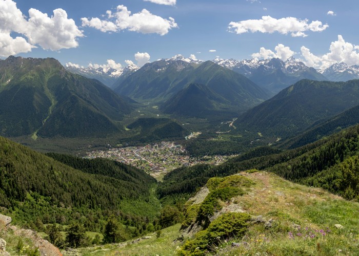
If you’re looking to explore the quieter side of the Alps, far from the tourist-packed ski resorts and souvenir shops, the Grande Traversata delle Alpi (GTA) might be the adventure you’ve been waiting for. Grande Traversata delle Alpi (GTA), Italy.
Stretching across northern Italy’s Piedmont region, this long-distance hiking route takes you through high mountain passes, remote villages, alpine meadows, and deep valleys. It’s a path less taken—but one that reveals the authentic heart of the Italian Alps.
Whether you’re planning a few stages or the entire route, this guide covers everything you need to know.
Overview: What Is the GTA and Why It’s Special
- What: The Grande Traversata delle Alpi (GTA) is a long-distance hiking trail running roughly 1,000 kilometers, connecting the Swiss border in the north to the Ligurian Alps in the south.
- Where: The trail follows the Piedmont Alps in northwestern Italy, skirting the borders of France and Switzerland.
- Why it’s famous:
- Crosses more than 50 alpine passes
- Connects ancient mountain villages, often untouched by modern tourism
- Offers views of Mont Blanc, Gran Paradiso, and Monviso
- Emphasizes slow travel and cultural immersion
Unlike more commercialized trails in the Alps, the GTA remains raw and intimate. Hikers often pass shepherds, stay in traditional mountain lodges, and walk trails used for centuries.
Best Time to Visit
The hiking season depends heavily on snowmelt and altitude.
- Best months: Late June to mid-September
- By late June, most of the snow in higher areas has melted.
- September offers cooler temperatures and fewer hikers.
- Avoid:
- October to May: Snow blocks high passes and many lodges close.
- July and August: While beautiful, they can be hot at lower altitudes and crowded in more accessible sections.
Early July and early September often offer the best conditions in terms of weather and accessibility.
How to Reach the GTA (Train, Road, Air)
You can begin the GTA at several different access points, depending on your desired route section.
By Air:
- Turin Airport (TRN) is the most convenient entry point.
- Milan Malpensa (MXP) is another option with international connections.
By Train:
- From Turin, regional trains go to towns like Susa, Cuneo, or Domodossola, all near starting points.
- Trains connect many lower valley villages, making segment hiking easier.
By Road:
- Renting a car allows flexibility but parking in alpine towns can be limited.
- Access roads are often narrow and winding in remote areas.
Because the trail spans multiple valleys, it’s common for hikers to use public transport between segments. Grande Traversata delle Alpi (GTA), Italy.
Entry Fees and Permits
- No general permit is required to hike the GTA.
- The trail is free and open to all.
- However:
- Some nature reserves may have local restrictions or voluntary donations.
- Mountain huts (rifugi) require advance booking and payment for overnight stays (prices range from €25 to €60 per night, meals extra).
Always check ahead if you’re crossing protected areas or national parks.
Food Availability and Meal Options
Food planning depends on how remote your route is.
- Mountain huts (rifugi): Offer hearty meals, typically Italian comfort food like pasta, polenta, local cheese, and bread.
- Village shops and bars: Available in lower valleys, selling basic supplies.
- Self-catering: Necessary in longer remote stretches; carry dry food like nuts, trail mix, canned goods, or freeze-dried meals.
Tip: Always carry 1–2 days of food in case of delays or hut closures.
Water is generally available from mountain springs or fountains, but purification tablets or filters are recommended in lower altitudes.
Packing List and Essentials
Packing light is key, especially on long-distance trails. Here’s what to bring:
Clothing:
- Moisture-wicking base layers
- Insulating mid-layers (fleece or down jacket)
- Waterproof outer shell (jacket and pants)
- Durable hiking boots (broken in)
- Hat, gloves, and buff
Gear:
- Lightweight backpack (40–55L)
- Sleeping bag liner (required in most huts)
- Trekking poles
- Headlamp
- Map and compass (or GPS)
- Water bottle or hydration system
- First aid kit
- Multi-tool or knife
- Sunscreen and lip balm
Optional but useful:
- Dry bags or stuff sacks
- Lightweight sandals for huts
- Power bank
- Notebook or travel journal
Weight matters—aim to keep your base pack under 10 kg if possible.
Safety Tips and Local Regulations
The GTA is well-marked in many sections but crosses remote, rugged terrain, so preparation is vital.
- Weather: Conditions can change quickly. Always check local forecasts.
- Navigation: Trails are often marked with red and white signs. Maps and offline GPS are helpful.
- Wildlife: You might encounter marmots, ibex, or chamois. Stay respectful and don’t feed animals.
- Emergency contact: Dial 112 in case of emergencies.
- Stay on the trail: Some areas border sensitive ecosystems or are private property. Grande Traversata delle Alpi (GTA), Italy.
Be aware that mobile signal is weak or non-existent in some mountain valleys.
Tips for Beginners or First-Time Visitors
While the GTA is not a technical mountaineering route, it’s not a walk in the park either.
- Start with a segment: Try a 3- to 5-day stretch before committing to the full trail.
- Train beforehand: Long climbs with heavy packs require solid fitness.
- Use huts: They reduce the need for carrying camping gear and offer a warm bed.
- Go with a partner: Solo trekking is possible but not advised for beginners due to remote sections.
- Watch your pace: Don’t overextend—it’s better to go slow and enjoy the journey.
Local Customs and Cultural Etiquette
Hiking the GTA means passing through small alpine communities, each with its own customs and dialects.
- Greet locals with a friendly “Buongiorno” or “Salve”
- Respect quiet hours in huts (usually from 10 PM)
- Leave no trace: Carry out all trash
- Be modest in dress, especially in rural villages and religious sites
- Cash is king: Many huts don’t accept cards
This is a chance to experience rural Italian hospitality and traditions not found in tourist hubs.
FAQ: Grande Traversata delle Alpi
How long is the full GTA route?
Around 1,000 kilometers, depending on the variation of trails used.
How many days does it take?
The entire GTA can take 6 to 8 weeks, but most people do shorter sections of 4 to 10 days.
What is the difficulty level?
Moderate to hard. Requires good fitness and comfort in high alpine terrain.
What is the altitude range?
Roughly between 800 and 2,700 meters, with many days spent above 1,500 meters.
Are there restrooms on the trail?
Restrooms are available in mountain huts and villages, but not on the trail itself.
Do I need to book mountain huts in advance?
Yes. Especially in peak season (July–August). Some can be booked online, others by phone.
Is wild camping allowed?
In some areas yes, but generally discouraged or regulated. Huts are the preferred option.
Are dogs allowed?
In general, dogs can hike, but not all huts accept pets. Check ahead.
Do I need a guide?
Not required, but if you’re new to alpine hiking or solo, hiring a local guide adds safety and context.
High-Search SEO FAQs for Google Visibility
- Grande Traversata delle Alpi hiking route
- Best time to hike GTA Italy
- GTA Italy trail difficulty and sections
- What to pack for the GTA trek
- Mountain huts on Grande Traversata delle Alpi
- How to reach GTA trail from Turin
- Long-distance hikes in Italy Alps
- Wild camping rules in Piedmont Alps
- Top alpine treks Italy 2025
- Is GTA suitable for beginners. Grande Traversata delle Alpi (GTA), Italy.


Leave a Reply